Manly Cove
 Manly Cove Coastal Zone Management Plan
Manly Council has prepared the Coastal Zone Management Plan (CZMP) for the Manly Cove area in response to legislative requirements and community issues following a process outlined in NSW Coastline Management Manual (1990).
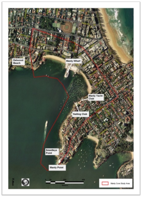
Manly Cove study area map lies immediately to the north-west of the entrance to Sydney Harbour, bounded to the west by Federation Point and to the southeast by Manly Point. It extends both seaward and landward from the shoreline and includes rocky intertidal platforms, sandy beaches, grassed recreational areas, a netted swimming enclosure, bushland as well as commercial, retail and residential areas.
Following the planning process, a Coastline Hazard Definition Study for the area was completed in April 2004.
Council actively engaged representatives of the Manly community, in the preparation and review of the Coastline Management Plan and encouraged residents to become involved in the management of their local area.
Structured survey forms were prepared and distributed to obtain community responses on importance, key issues and specific suggestions for inclusion in the Coastline Management Plan. A total of 89 survey forms were returned.
From surveys, popular activities for users of the Manly Cove area include walking/jogging (84%), swimming (68%), passive recreation (63%), picnicking (53%) and commuting (43%).
KEY MANAGEMENT ISSUES
A long list of management issues was identified mainly from filled in survey forms. Further, specific local issues were derived during two community consultation field days. The issues are summarised under the following key broad based management issues:
- Aquatic/Inter-tidal Habitat Conservation & Management
- Boating, Maritime Operations & Facilities
- Upgrading & enhancement of public facilities, Infrastructures & signage
- Water Quality
- Terrestrial Ecology
- Coastal Hazards & Climate Change
- Waste Management
- Access & Traffic Management
- Recreational Activities & User Groups
- Geodiversity
- Heritage Conservation & Management
Manly Cove Coastline Management Study
Manly Cove Coastline Management Study , endorsed by Council at its Planning & Strategy Committee meeting dated 7 December 2009, is a baseline document describing institutional and policy environment; land use tenure & management; significance of the area; coastal processes; coastline hazards; climate change & adaptations; ecological environment; socio-economic environment; community consultations; framing vision and goals; strategic management options and preliminary assessment of management options.
Manly Cove Coastal Zone Management Plan
The Manly Cove Coastal Zone Management Plan (CZMP) was adopted by the Council at its Planning & Strategy Committee meeting on 7 November 2011. Prior to this, public exhibition of the Plan occurred during 20 June to 16 September 2011 and a final endorsement of the Plan by the Harbour Foreshores & Coastline Management Committee on 11 October 2011.
This Coastal Zone Management Plan is a strategic plan with a long-term time frame of 15- 20 years and firmed up implementation program of 5 years. This plan will be reviewed and revised every 5 years and a new implementation program will be adopted in line with priorities of the period.
This Plan sets 10 Goals and 25 Objectives to be addressed through 66 Management Options. Only 34 of these are new activities. Of these 34, seven management options are proposed for immediate implementation, 15 within 2 years, 10 within 3-4 years and only two at later years. Overall, 32 management options have been rated to have high priority, 29 as medium priority and five as low priority.